
|
|
)
)
)
)
|
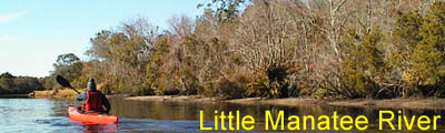
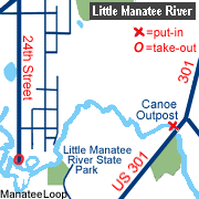
Description The Little Manatee River is located in southeastern Hillsborough County and flows from swampy beginnings near the town of Fort Lonesome for nearly 40 miles to Tampa Bay south of Ruskin. The river is generally shallow with a white sandy bottom and numerous small beaches great for taking a quick break. The lower part of the river is influenced by the tide in Tampa Bay. In 1982 the river was designated as an Outstanding Florida Water as part of the Cockroach Bay Aquatic Preserve. Located south of the river between US 301 and 24th Street is the Little Manatee River State Recreation Area. This 2,433 acre park opened in 1987 and features sheltered picnic areas and campsites with electric and water hookups. The park also provides a very nice canoe launch and a 6.5 mile hiking trail. Fishing opportunities abound on the Little Manatee with bass, bream and catfish waiting for your lure.
Access The Little Manatee River is located less than 45 minutes from downtown Tampa, St. Petersburg or Sarasota. From Tampa, go south on I-75 to Sun City Center (exit 240A, old #46B). If you are providing your own shuttle or starting at the 24th Street river access, turn west (left) on College Avenue. Turn south (left) on 24th Street and follow all the way to the river. Leave a car here. To find the put-in at Canoe Outpost, go east on SR 674 (Sun City Center Blvd) to US 301. Proceed south on US 301 for 3 miles to the bridge crossing the Little Manatee River. Turn in the driveway for Canoe Output. You can park by the bridge for free (first right) or at Canoe Outpost for a small fee.
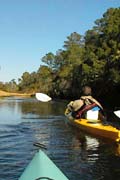
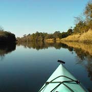
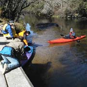
Tour #1: Canoe Outpost (US 301) to 24th Street (6 miles) Please note: This trip requires a shuttle from the take-out at 24th Street back to the Canoe Outpost. The Canoe Outpost (phone 813-634-2228) provides this service for a modest fee. If you shuttle your own vehicles, leave one car at the 24th Street take-out and take your primary vehicle (with boats and gear) to the Canoe Outpost on US 301. Begin by paddling downriver at the Canoe Outpost. For the first two or three miles of the trip the river meanders through scenic pine scrub, oak and cypress woodlands. In this section you are likely to encounter a number of deadfalls, overhangs and other obstructions waiting to catch you off-guard. Unless the water is at an extremely low level, portaging should not be necessary. At approximately mile 3 you will see large concrete steps on the south bank. This is the canoe launch of the Little Manatee River State Recreation Area. At the top of the launch is a few picnic tables and restrooms. Proceeding about 10 minutes more downriver will take you to another picnic area in the park. After the picnic area the river broadens and becomes influenced by the tide. From this point the environment begins to change from woodland to more of a marsh while the river slows and becomes shallower. You will begin to see housing developments along the north bank during the last mile of the trip. The take-out is located at 24th Street by the power lines crossing the river. Tour #2: "Manatee" Loop (3 miles) The Manatee Loop, named for the Manatee that can be occasionally found in this area, adds an additional 3 miles to tour #1. Begin at the 24th Street put-in. This is a small sandy beach and parking area. Proceed downriver under the power lines. Be sure to remember this landmark. About 15 to 20 minutes from the put-in, you will come to a fork in the river with a small white sign reading "LOOP". Turn left following the arrow. This will take you around the backside of the island. Initially this section starts fairly wide but quickly narrows. Look for another white sign reading "THIS WAY". This sign points you up a narrow stream that will take you back to the main river. Once you reach the main flow of the Little Manatee River, turn downstream and proceed back to the 24th Street put-in. Tour #3: 24th Street to Live Oak Park (6 miles) This trip goes west under I-75 and through the lower section of the river. Here the river is greatly controlled by the tides, so some parts may be shallow if you attempt the trip at low tide. Begin at the 24th Street put-in and immediately proceed downriver. The river branches a number of times as it heads toward I-75. Always take the left fork (following the main flow) as you go downriver. Do not turn left at the "LOOP" marker or you will go in a circle (See tour #2 above). At about one mile, you will come to an area with high sand bluffs
and small beaches that are exposed at low tide. At two miles, you
will reach the I-75 bridge. Approximately one mile past the bridge,
begin to watch the south bank for the small boat ramp signaling
Live Oak Park. The park does not have restroom facilities, but does
have a few picnic tables where you can enjoy lunch. Reverse the
process to head back towards the 24th Street put-in. Always turn
right when going upriver.
|
||||||||||||||||||||||||||||||