
|
|
)
|
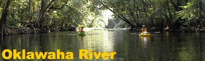
Description The scenic Oklawaha (also called Ocklawaha) River follows the edge of the Ocala National Forest in central Florida and is one of the State's only south to north flowing rivers. The river is famous for its incredible array of flora and fauna and diverse bio-habits and great paddling opportunities. For history buffs, in the late 1800's steamboats and barges noisily traveled along the Oklawaha river carrying people and goods from Jacksonville to Silver Springs. The boats were much smaller than those found along the Mississippi due to the Oklawaha's narrow twists and turns.
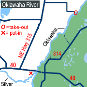
Access At the junction of I-75 and SR 40 (exit 352, old #69) in Ocala, turn east (right) on SR 40 and go 9 miles to the Silver Springs attraction. Continue past the amusement park on SR 40 for 2 miles. Turn north (left) on County Road 315. Go north towards Fort McCoy for approximately 6 miles. Turn right at sign indicating Gores Landing (N.E. 150th Street). The campground and boat launch is approximately 3 1/2 miles from CR 315. Leave a car at the campground parking lot. Return to the intersection
of SR 40 and CR 315. Turn east (left) on SR 40 and go 1 mile to
Ray Wayside Park. The park is west of Delks Bluff Bridge. A canoe
launch is located at the far end of the park just past the boat
ramps.
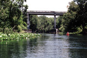
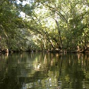
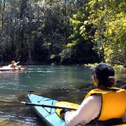
Tour: Ray Wayside Park to Gores Landing Note: This trip requires a 12 mile shuttle from the take-out at Gores Landing returning to Ray Wayside Park. Leave a car at Gores Landing and take your primary vehicle (with boats and gear) to the put-in. To begin, start at the Ray Wayside Park canoe launch and paddle 200 yards along the canal to the Silver River. If you have the time, Silver River offers crystal-clear spring fed waters with white sandy bottoms and an abundance of wildlife. After a brief diversion paddling up the Silver, reverse direction and head downstream. Delks Bluff Bridge, the overpass for SR 40, lies just past where the clear waters of the Silver meet the tannin stained Oklawaha River. The trip downriver is easy to paddle with a 3 MPH current. Always be on the lookout for deadfalls, napping alligators and erratic motorboat operators. Continuing northeast from the bridge, the river passes through several narrow sections with high limestone bluffs and small sand beaches that offer a nice place to take a quick break. About three-quarter way to the take-out, you'll come across abandoned buildings and cleared yards that once belonged to local farmers. Prior to reaching Gores Landing on the south side of the river is a passageway to the Dead River area. Should you decide to take this one extra mile diversion, the river meets up with the Oklawaha a few hundred feet from Gores Landing. Trees along the river form a beautiful canopy as you near the park. Be on the lookout for a troop of wild Rhesus monkeys. Legend has it the monkeys are descendants of escapees from Tarzan films shot at Silver Springs; however the Silver Springs web site lists the source as Colonel Tooey, concessionaire who operated the Jungle Cruise boat ride during the 1930s. Evidentially the good Colonel put the monkeys on an island in the river without realizing they are capable swimmers. While the monkeys are fun to photograph and watch, be careful to stay a good distance away from them as they bite, scratch and are generally ill mannered. You can spot the take-out at Gores Landing by the canoe launch (sandy beach) and small channel to the boat ramp on the north side of the river. Gores Landing is a Marion county park offering river access, picniking, restrooms and camping (fee required).
|
|||||||||||||||||||||||||||