
|
|
)
)
|
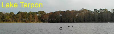
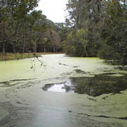
Description Lake Tarpon, located south of Tarpon Springs has been called "The Jewel of Pinellas County". This freshwater lake is approximately five miles long, one mile wide and covers 2,500 acres. What makes Lake Tarpon a jewel? In two words, Bass Fishing. Lake Tarpon is regarded as one of the foremost sport fishing lakes in Florida and attracts fishermen (and fisherwomen) from all over Florida and even surrounding states. You might want to bring a pole and give it a try. Besides largemouth bass, bluegill, sunfish, blue tilapia and catfish provide sport and a yummy meal. Fishing licenses are required for all individuals between the ages of 16 and 65. Other restrictions may apply so check postings at either Anderson or John Chesnut parks. Secondary to fishing, Lake Tarpon attracts power boaters, including
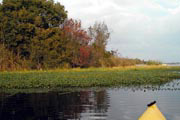
personal watercraft users and water skiers. To a lesser extent,
sailboats, canoes and kayaks can be found on the lake. While the
constant barrage of engine sound can drive a paddlesport enthusiast
crazy, the lake offers a variety of wildlife viewing and many interesting
areas to explore.
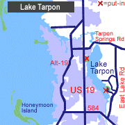
Access Lake Tarpon is located southeast of Tarpon Springs, FL. The two primary public access points are Anderson Park (North) at 39699 U.S. Highway 19 North, Tarpon Springs and John Chesnut, Sr. Park (South) at 2200 East Lake Rd, Palm Harbor, FL. Entrance and parking at both parks is free.
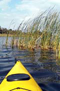
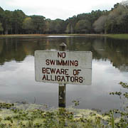
Tour #1: Salmon Bay / Anderson Park (1.5 miles) For those lucky enough to live in the northern Pinellas area, a quick paddle around Salmon Bay may just be what the doctor ordered. Salmon Bay is part of Anderson Park and can be found two miles south of Tarpon Springs on U.S. Hwy 19. The park is 128 acres in size and offers group picnicking facilities, elevated boardwalks with nature trail and a boat ramp. Put-in at the boat ramp to begin the trip. Immediately turn left (North) and follow the edge of the bay in a clockwise fashion. Those paddlers with a keen eye can spot many different types of birds including American coot, grackles, seagulls, osprey and even an occasional bald eagle. There are many small inlets off Salmon Bay that are just waiting to be explored. You will no doubt spot a few alligators along the way. As you reach the entrance of Salmon Bay (from Lake Tarpon) be sure to watch for boats. Most travel at high rates of speed through this area so make the crossing quickly. On the other side, you can resume a leisurely pace and enjoy the rest of the trip back to the boat ramp. Tour #2: Salmon Bay to John Chesnut Sr. Park (8 miles) If you're seeking a longer paddle at Lake Tarpon, a trip from Salmon Bay in Anderson Park to John Chesnut Sr. Park will take you on an 8 mile adventure (round trip). To begin, put-in at the boat ramp and paddle approximately 1/2 mile east toward the bay entrance. Rounding the point will take you past a nice picnic area. Watch for fishing lines in the water as many anglers also enjoy this spot. Head south once you reach the open waters of Lake Tarpon. Follow the shoreline for 2.5 miles past numerous small coves. You can tell you've reached Dolly Bay as the homes get larger and more expensive. Continue south for another mile. The lake is much narrower here and looking east (across the lake) you should see the boardwalk at John Chesnut Sr. Park. Carefully paddle the one mile crossing toward the boardwalk. As you get closer to the east side of the lake, you should be able to see a lookout platform and south of that, a playground and picnic shelters. The shelter just south of the playground is #9 (See GPS locations). Stop here for a well deserved rest. If you feel like paddling further and don't mind a portage, you might want to explore the inland canoe trail. Otherwise retrace your path back to Salmon Bay and Anderson Park. A note about crossing Lake Tarpon. It can be dangerous, even foolhardy, to make the crossing if there is much boat traffic or high winds. The lake will get rough between the wakes created by boats and the wind driven waves. Special Interest: The "U" shaped canoe trail at John Chesnut Sr. Park is a .6 mile landlocked waterway that begins by shelter #9. Those paddlers without fear of alligators and snakes may take twisty trail under five sets of bridges to the interior lake. Paddling to the end of the lake (near the remains of a fairly large windmill), will put you within 200 yards of your starting point. It's probably too far to carry your kayak, but it makes driving the shuttle vehicle a snap. For the land lover, the 255-acre John Chesnut Sr. Park also features
picnic shelters, playground equipment, a softball field, volleyball
court, fishing pier and three nature trails including elevated boardwalks
and lookouts.
|
|||||||||||||||||||||||||