
|
|
)
)
)
)
|
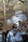
Description The Hillsborough River flows over 50 miles from the Green Swamp near the origin of the Withlacoochee River (by Lakeland Florida) to Hillsborough Bay (Tampa). The upper 31 miles of the river from Crystal Springs in Pasco County to Riverhills Park in Temple Terrace are an official Florida Canoe Trail. Along the canoe trail, the Hillsborough River State Park (12 miles north of Tampa) has Florida's only Class II rapids. Before you get your whitewater boat ready, you should know that kayaking and canoeing the small limestone rapids is not allowed. For flatwater trips, you can put-in at numerous locations along the Hillsborough River and paddling either direction is easy as the current is usually slow.
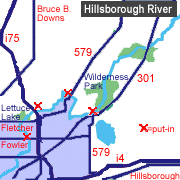
Access From Tampa, go to the junction of I-75 and Fletcher Avenue (exit 266, old #55). Go east 1/2 mile on Morris Bridge Road. The first left is Trout Creek Park (a Wilderness Park site). Travel four miles east on Morris Bridge Road for the Morris Bridge Wilderness Park. For a day long one-way trip, you can start at Sargeant Park (6 miles north of Fowler Avenue on US 301).
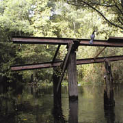
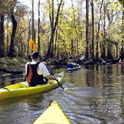
The Hillsborough River tour is divided into four segments, allowing you to paddle them all at once (14 miles one-way, requiring a complete day), or try each section individually. If you want to go the distance, leave a shuttle vehicle at Rotary Park located at Fowler Avenue and Morris Bridge Road. Proceed east for one mile on Fowler Avenue until you reach US 301. Turn north (left) and go approximately 6 miles to Sargeant Park. This small park is located on the west side of the roadway. Tour #1: Sargeant Park to Morris Bridge Park You can paddle this section of the river one-way for a distance of 4 miles, or double that (8 miles) by starting at Morris Bridge Park and paddling up river to Sargeant Park and back. The trip in either direction is easy due to slow current, but be prepared to go over and around a few deadfalls in the river. About 1/2 mile from Morris Bridge Park, you'll paddle by an old railroad trestle. Tour #2: Morris Bridge Park to Trout Creek Park Morris Bridge to Trout Creek is my favorite section for viewing wildlife, especially alligators. This scenic trip is approximately 4 miles (one-way). For the first three miles downstream, the river is quite narrow and you'll need to be careful of deadfalls and stumps hiding just below the surface of the river. The water is clear with a 1-2 MPH current. At approximately mile 3, you'll come to the Southwest Florida Water Management District dock (no access). The water in this area is shallow and rarely exceeds one foot in depth. Expect to see many turkey vultures by the dock. During one trip, we spotted a male peacock mixed in with the vultures. Proceed one mile downstream to Trout Creek Park. Trout Creek Park has restrooms, picnic tables and a canoe wash. Tour #3: Trout Creek Park to Lettuce Lake Park For this 3 mile section (one-way), start at Trout Creek Park and paddle downstream to Lettuce Lake Park. Besides the flood control dam at 1/4 mile downstream, this part of the river is fairly pristine with little human activity. Along the river you will see an abundance of wildlife including wading birds, turtles, snakes and alligators. Lettuce Lake received its name due to an abundance of small floating plants called Water Lettuce. The plant is light green with lettuce-like leaves. Once you reach Lettuce Lake Park, take a break at the convenient picnic shelters about 300 yards down river from the Observation Tower. A nature center, restrooms and trail/boardwalk are close by. On the west bank of the river is the University of South Florida River Park. The University offers canoe and kayak rentals for students and facility. (Also a nice grassy area and picnic tables should you choose to visit). If you are paddling roundtrip, retrace your steps to finish at Trout Creek Park, for a total of 6 miles. You can tell when you're close to Trout Creek Park by listening for the sound of traffic on I-75. Tour #4: Lettuce Lake Park to Rotary Park The final 2.5 miles of the tour from Lettuce Lake to Rotary Park is developed with housing on both sides of the river. Here the river widens and is a dark brown, almost black color. If you keep a keen lookout, you just might spot a big 'gator or two lazily warming themselves in the Florida sun. The take-out at Rotary Park (Morris Bridge Road and Fowler Avenue) is located immediately upriver of the Fowler Avenue bridge. The park has restrooms, picnic tables and a concrete boat ramp. Should you decide to continue your Hillsborough River adventure, you can paddle downstream under the Fowler bridge and past Busch Boulevard to Riverhills Park. Note that you cannot put-in at Lettuce Lake Park, so if you want
to do a roundtrip on this section of the river, start at Rotary
Park, paddle up to Lettuce Lake and back for a total of 5 miles.
|
||||||||||||||||||||||||||||