
|
|
)
)
)
|
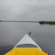
Description The area around Homosassa River is known for world-famous fishing. In the freshwater springs bass, bream, catfish and bluegill abound. The saltwater angler can cast a line for schools of sea trout, redfish, grouper, snapper, tarpon and mullet. But fish aren't the only creatures stirring these waters. Paddlers of all shapes and sizes regularly ply up and down the Homosassa in search of nature, solitude, adventure and yes, even the chance at hooking the lunker of a lifetime. The source of the Homosassa River is a crystal-clear spring located within the state-owned Homosassa Springs Wildlife State Park. Here you can view many different species of indigenous plants and animals and one of the largest herds of West Indian manatee in the State. If your visit coincides with the winter months, you may be able to spot the gentle gray giant from your canoe or kayak at the park boundary.
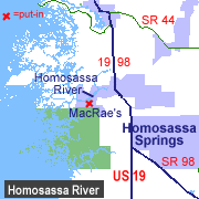
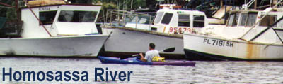
As the river makes its way to the Gulf of Mexico, the water mixes with saltwater and becomes brackish. Anglers delight at the fishing opportunities, and several state and world-record catches have been pulled from this area. Continuing west, the Homosassa dumps into the Gulf amid many small mangrove islands and saltwater grassy flats. At five miles downriver from the put-in at MacRae's you'll find Hell's Gate, a narrow slot in the river known to eat powerboats. Its strong current eats canoeists and kayakers too. Access Homosassa is located 7 miles south of the City of Crystal River. Travel south on US 19 to the town of Homosassa Springs and turn west on Yulee Drive (County Road 490). Follow signs to the Yulee Sugar Mill ruins. Stay on Yulee until reaching MacRae's Motel. A boat ramp and dock are available to the public at no charge. Bait-and-tackle, snacks and powerboat rentals are also available at MacRae's.
Tour #1: Sam's Bayou (9 miles) The trip to Sam's Bayou takes approximately 3 to 4 hours and covers sections of three different coastal rivers. Sam's Bayou offers the opportunity to explore subtropical forests, coastal marsh, excellent wildlife viewing and solitude. Be sure to bring plenty of water as fresh water is not available anywhere on the route. It is also important to have a good marine / topo map and compass or GPS unit. Sam's Bayou is located in a remote area where it's easy to become disorientated. Spending the afternoon paddling around lost in a saw grass marsh is not a lot of fun.
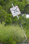
Turn around and proceed downriver to Channel Marker 72 (red #2). Be sure to keep track of where you're paddling and stay out of the main channel as power boat traffic is prevalent in this area. Near Channel Marker 72, you should see Nature Coast Canoe Trail Marker 23 on the north bank of the river. Last time we were on the river it was partially hidden by foliage and not readily visible so it might take some searching to find it. Go north and follow the canoe trail markers along the Salt River and into Shivers Bay (#3). Continue north through the bay and turn west onto the Little Homosassa River. This river starts at the northwest end of Shivers Bay. Sawgrass, oyster bars and an occasional patch of trees will accompany you as you follow the south bank of the Little Homosassa River. The river eventually splits going north-northwest and Southwest. Continue southwest to the beginning of Sam's Bayou (#4). Depending on the tide, this area can be very shallow with strong currents. Oyster bars are prevalent. Continue south-southeast. The entry to Sam's Bayou is narrow and difficult to locate. In this area you should be able to find several places with trees and limestone outcroppings that make a nice place to stop for lunch. To make the trip back, continue east from Sam's Bayou. Approximately 1/2 mile down river, you'll come to a split in the river. Taking the left split will quickly take you back to the main channel of the Homosassa River at Channel Marker 65 (#6). Paddle north back to MacRae's. Tour #2: Homosassa Springs (5 miles) The trip to the Homosassa Springs Wildlife State Park takes approximately two hours and covers five miles. To begin, start at MacRae's boat ramp. Paddling north for 200 yards will take you to Monkey Island. Continue north along either bank of the Homosassa for 1.5 miles. Here the river splits in two directions. Hall's River is northwest of this point (under the bridge) and makes a fine place to explore. For Homosassa Springs, continue northeast for 3/4 mile. The river narrows considerably and houses line both banks. Just past the last house, you'll enter the wildlife park area. A covered wooden viewing platform can be seen on the east bank of the river. Park boundary signs posted in the water limit further upstream access, but you'll still see plenty of wildlife (both nature and human-related) in this area. Near the boundary signs, the water clears considerably and you can see the sandy river bottom, along with numerous fish, turtles and for the lucky paddlers, a manatee or two. To return to MacRae's, track-back along the same course that brought you here. Special Interest Homosassa Springs Wildlife State Park This state-owned facility is a showcase for Florida
wildlife. The park features Florida Panther, alligators, crocodile,
manatee, deer, flamingos and other animals and birds of prey. Visitors
can take a boat tour of Pepper Creek or go underwater without getting
wet at the floating observatory. From the observatory, you can see
thousands of fish and an occasional manatee. The park is open 9-5
daily and is located at 9225 W. Fishbowl Drive.
|
|||||||||||||||||||||||||||||||||||

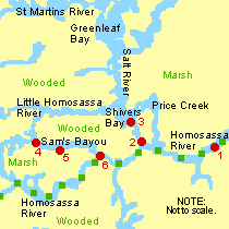 To begin, launch from MacRae's boat ramp (red #1 on map & GPS
Location Aid). Paddling up-river for 200 yards will take you to
Monkey Island. Here semi-tame monkeys live on a small island that
has been decorated with buildings, rope swings and a lighthouse.
The monkeys are fed by nearby restaurants and kind paddlers.
To begin, launch from MacRae's boat ramp (red #1 on map & GPS
Location Aid). Paddling up-river for 200 yards will take you to
Monkey Island. Here semi-tame monkeys live on a small island that
has been decorated with buildings, rope swings and a lighthouse.
The monkeys are fed by nearby restaurants and kind paddlers.