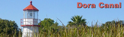
| Dora
Canal |
 |
| Difficulty: Basic |
Scenery: Fair |
Location: Mount Dora,
Lake County |
Distance: 4.5 miles
round trip. |
| Atlas: Page 79 B-2 |
| Last Update: December 2003 |
Canoe OK: Yes |
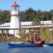
 Photo-trip
- limited details. Photo-trip
- limited details.
Description
When most people think of paddling Central Florida, the Dora Canal
does not immediately come to mind. It's a small 1.25 mile tree and
mobile home-lined waterway connecting Lake Dora on the south with
Lake Eustis on the north. So why include it in Central Florida Kayak
Trips? Well, that's simple to answer.
Even with the lack of pristine nature and a short distance (about
2 hours to complete the trip); the Dora Canal and surrounding community
can be one heck of a good time. If you are interested in bird watching
or photography, this place makes it easy. The tree canopy in the
center of the canal is home to thousands of wading birds. Most of
them have seen scores of people and boats and are unafraid when
you point a camera at them. Just watch the lighting; sunlight through
the trees make it a respectable challenge.
The second reason you'll want to paddle the Dora Canal is to explore
Mount Dora. Just 30 miles northwest of Orlando at the east end of
Lake Dora is Mount Dora, a wonderful little New England-style town
known for its historic bed and breakfast inns, antique and gift
shops, fashion boutiques and restaurants. The City got its unusual
name because of small rolling hills and sitting at a stratospheric
186 feet elevation, higher than most locations in Central Florida.
So now if you see a "I climbed Mount Dora" bumper sticker
you'll understand the inside joke.
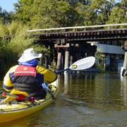
Access
From Mount Dora, take Old US 441 west to the small town of Tavares.
Turn south (left) on Dora Ave. Turn west (right) on Main Street.
Follow Main Street to Rockingham Ave. Turn south (left) on Rockingham
Ave and go one block to Wooten Park.
If you are north-bound on Highway 19, go to Main Street in Tavares
(just past Dora Canal bridge). Turn east (right) and go to Rockingham
Ave. Turn south (left) on Rockingham Ave and follow to Wooten Park.
Dora Canal Photographs
|
Lake Dora
Lake Dora is part of the Harris Chain of nine lakes connected
by canals and streams. Dora is a shallow (average 10' deep),
dark-stained freshwater lake with cattails, Kissimmee grasses,
reeds and other aquatic plants near the shoreline. Water flows
north through the Dora Canal to Lake Eustis and eventually to
the Oklawaha River. |
|
Dora Canal
Originally named the Elfin River, it is frequently written the
Dora Canal is the "Most beautiful mile of water in the
world." Not to debate the point, but in terms of paddling
it's rated fair due to extensive development at both ends of
the 1.25 mile canal. In between is a great place to photograph
birds and other wildlife. |
|
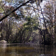
Tree Canopy
Much of the middle section of the Dora Canal is covered by a
Cypress tree canopy. The canopy provides a nice shady place
for the local bird population. Several canals leading west make
interesting side trips; most dead-end eventually into housing
areas. |
|
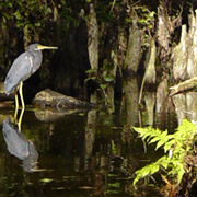
Little Blue Heron (adult)
Egretta caerulea
In the dense sub-tropical growth along the canal, one of the
more common birds you'll see is the Little Blue Heron. The adult
Little Blue Heron has a slate-blue body and wings with dark
purple head and neck. Young (immature) birds are all white in
color. |
|
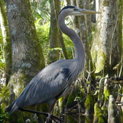
Great Blue Heron (adult)
Ardea cerodias
This large member of the heron family is very common to the
Dora Canal area. Adults can reach over four feet in height with
a six foot wing span with a blue-gray back and wings. Legs are
long and typically dull-yellow in color. |
|
Lake Eustis
Just north of the Highway 441 bridge lies Lake Eustis, a 7,800
acre lake known for bass fishing and sailing. The Buzzard Beach
boat ramp and park is about 1/2 mile west of the bridge and
makes a convenient spot to rest and enjoy lunch.
If you don't mind an extra 2 miles, go for a wonderful Florida
Cracker-style lunch at Dead River Vic's. It's located on the
Dead River between Lake Eustis and Harris. You can find the
entrance to the Dead River about 1 mile west of Buzzard Beach.
(Restaurant is on Hwy 441 at the Dead River Bridge). |
References
Alden, P., Cech, R., Nelson, G. (1998) National Audubon Society
Field Guide to Florida, Chanticleer Press, Inc., New York, NY
|

)
)