
|
|
)
)
)
|
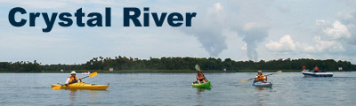
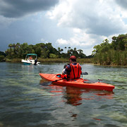
Description Crystal River is famous for two things; manatees and the people who come to view them. And during the winter months of December to March, you can expect to find plenty of both. The freshwater spring fed river starts south of the City of Crystal River and flows seven miles to the Gulf of Mexico. As it approaches the Gulf, the river becomes tidal influenced and the scenery changes from highly developed freshwater bays and canals to sawgrass marshes, mud flats and open water.
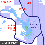
Access From Crystal River, go south on US 19 to W. Fort Island Trail. Turn west (right) and go five miles to Fort Island Trail Park. Follow signs to the boat ramp. A shorter paddle trip can be made by starting at Pete's Pier Marina in Crystal River. From US 19, turn west on S.E. Kings Bay Drive. Go to SW 1st Place. Turn right. The marina is located in Kings Bay just to the east of Buzzard Island.
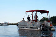
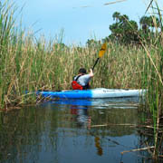
Tour: Fort Island Trail Park to Kings Bay (7.5 miles) This trip starts at Fort Island Trail Park located southwest of the City of Crystal River. Upon entering the park, follow signs to the boat ramp. You'll need to unload quickly as the ramp is a popular put-in for those visiting Kings Bay or the Gulf of Mexico. From the boat ramp, go down the short canal and turn east (right) at the main river. A fishing pier immediately to the west of the canal will help guide your return to the park. At this point the river is several hundred yards wide with a slow moving, tidal influenced current. As you make your way upriver to Kings Bay, it's best to remain on the south side of the river as housing developments and the boat channel tend to be located on the north bank. If you have time, there are two short but interesting diversions near the fishing pier. The first side trip starts about 300 yards east of the fishing pier. Look for openings leading into the sawgrass. Some of the longer passageways twist and turn for several hundred yards through the sawgrass marsh before terminating in channels too narrow to navigate. The second side trip is located about 1/2 mile from the pier. A channel marker and small sandy beach, exposed only at low tide, mark the entrance to a canal leading south toward W. Fort Island Trail. Here you can escape the much of the boat traffic encountered on Crystal River and paddle swamp-like areas surrounded by palm and pine trees and saw palmetto. If you look closely, you're sure to spot an alligator or two. Across the river from this point is the Crystal River State Archeological Site. As you enter Kings Bay at three miles upriver, you'll see Buzzard Island straight ahead, with Pete's Pier Marina on the northeast side of the bay. On the north side of Buzzard Island is a small ship partially submerged in the river. Continuing east to the headsprings will reveal Parker Island to the northeast, Banana Island in the center of the bay and Warden Key on the southeast. While it's tempting to land on these islands, signs indicate they are off-limits to human activity. A popular shallow water "beach" lies between Banana and Parker Island. To find Kings Spring (the headsprings) go to the backside of Banana Island. You'll quickly spot all of the dive boats. A dive shop, marina and restaurant are conveniently located within a few hundred yards of the headsprings. All are paddler friendly so stop in and enjoy lunch while watching the divers perform checkout dives or look for manatees in the headsprings. To return to the put-in at Fort Island Trail Park, simply head downriver for about 3.5 miles. You're close when you can see the fishing pier. Special Interest Crystal River State Archeological Site For approximately 1,600 years (200 BC to 1400 AD), the Crystal River State Archeological Site and surrounding areas were used by early Native Americans for ceremonial activities, hunting, food gathering and trading. At one point, it is estimated that 7,000 to 10,000 people lived in the vicinity. Today, the State-owned Park covers 14 acres of land containing six shell "middens" and a visitor center which houses a museum, gift shop and park office. A one-half mile paved trail leads visitors past each of the middens, which reach heights of 30 feet and over 50x100 feet in size. The middens are constructed of oyster, mussel and other types of shells, along with household materials and remnants of food stuffs. Stairs going up Temple Mound "A" lead to an observation deck offering a wonderful view of the Crystal River. The archeological site is located 2.5 miles west of US 19 at 3400 N. Museum Point in Crystal River. A small admittance fee of $2 is charged per vehicle. Crystal River National Wildlife Refuge The Crystal River NWR is a 46 acre refuge consisting of several small islands surrounded by Kings Bay. The refuge is dedicated to preserving critical manatee wintering habitat. Primary human use of the refuge is scuba diving, diver training, snorkeling, boating and wildlife observation. The refuge is home to one of the densest concentrations of manatees in the State of Florida and the best time to see manatees is from December to March. On weekends also expect to see numerous boats and divers on the water with heavy crowds in the corridor between Banana Island and Sunset Shores. Remember, by law, you cannot approach a manatee, but if it comes up to you, it's ok to touch it with one open hand. From November 15 to March 31 the refuge has designated manatee sanctuaries surrounding Banana Island and to the north of Buzzard Island, Sunset Shores and Warden Key. These areas are off limits which allow manatees a place to feed and rest undisturbed.
|
|||||||||||||||||||||||||||||||