
|
|
)
)
)
)
|
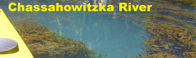
Description Chassahowitzka, pronounced "Chaz-wits-kuh", consists of a series of freshwater springs; river and U.S. National Wildlife Refuge (NWR). Located 60 miles north of Tampa and St. Petersburg on the gulf coast of Florida, the 31,000+ acre refuge was created in 1943 as a winter preserve for migratory waterfowl. In addition to plenty of bird watching opportunities, a keen-eyed canoeist or kayaker can spot manatee, raccoons, otters, numerous alligators and possibly even deer, bobcat or a Florida black bear. The headwaters of the river start approximately 100 feet upstream from the Chassahowitzka River Campground's boat ramp. A first magnitude spring and smaller 2nd magnitude springs in the area create the river which flows 7 miles west to the Gulf of Mexico. The wildlife refuge starts three miles downstream from the campground. The northern boundary of the NWR parallels the Homosassa River, with the southern end 12 miles south at Raccoon Point. Access to the National Wildlife Refuge is by boat only with the best put-in for paddlers at the campground.
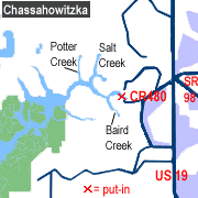
Access From Weeki Wachee take US-19 north 13 miles to CR 480 (Miss Maggie Drive). Go west (left) on 480 for approximately 1.5 miles to Chassahowitzka River Campground. Follow signs to boat launch. Be sure to ask for a canoe map when you pay the parking fee.
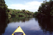
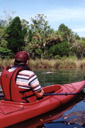
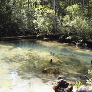
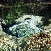
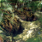
Tour #1: The Springs Loop (7 miles) The Springs Loop will take you through seven of the more easily accessible springs along the Chassahowitzka River. If you make the trip on a weekday, you'll probably have most of the springs and river to yourself. On weekends, plan on sharing these wonderful springs with a few boaters (paddle and motorboat variety). Arrive early in the day to have a parking space at the campground. Please note that some of these springs are located in remote, deep woods areas. You should be comfortable with using a map, compass, GPS or other navigational tool prior to making the trip. Chassahowitzka Springs: To begin, put-in at the campground's boat ramp. Paddle 100 feet upstream (east). Congratulations, you've made it to the first spring. The opening to the spring is about 20-30 feet deep in the upper portion of the basin. Swimming and diving are prohibited due to motorboat traffic. Unnamed Springs: The next set of springs can be found just a few hundred feet to the east of the main spring. Enter the manmade channel (left as you are paddling east), and go about 75 feet. The spring run is between 1 and 2 feet deep in most places, so it's easy to exit your boat for photos or a quick swim. Water flowing from the springs is clear and appears to be a radiant blue when viewed in direct sunlight. By paddling the length of the spring run, you should be able to spot at least 8 different vents feeding the springs. Crab Creek Springs: Starting at Unnamed Springs, head downstream about 200 yards past the boat ramp. The entrance to Crab Creek is located on the north side of the river. The spring run is jungle-like and about 100 yards in length. You'll see two beautiful homes immediately adjacent to the springs. You can visit the springs, but all surrounding land is private property. The water is full of particulate matter and is 6 to 8 feet deep with a light blue color at the three spring vents. Blue Springs - Baird Creek: From Crab Creek Springs, head downstream and paddle along the Chassahowitzka River for approximately 1/2 mile. Turn south (left) to Baird Creek. You can identify the entrance by a tiny island, complete with palm trees, marking the pathway. Baird Creek is a narrow, shallow (1-2 feet deep), twisty, jungle-like waterway enclosed by sawgrass and trees. If you are terrified of the possibility of running into alligators, snakes or swarms of mosquitoes you might want to skip Blue Springs and The Crack. For those brave enough to continue on, slap on generous amounts of insect repellent and start the 1/2 mile paddle to the springs. This tiny partially canopied waterway offers some tremendous photo and wildlife viewing opportunities. Blue Spring forms a small lagoon, about 100 feet in diameter. The water is a dark, cloudy blue so it's not possible to see the bottom. Much of the pool is surrounded by sawgrass and trees, but you can dock along the backend of the pool for either a quick dip or well-deserved break. The Crack - Baird Creek: The entrance to the Crack can be found at the backend of Blue Springs. Look for a small opening between two large palm trees. The waterway here, like much of Baird Creek, is narrow and shallow. Pass the two small turquoise-colored pools and continue upstream until the water becomes too shallow to paddle. You'll need to exit your boat and hike the remaining 200 feet through ankle deep water to the spring.
Salt Springs - Salt Creek: After returning to the main channel, paddle downstream for 1/3 mile. Here you will encounter a large island that divides the river. The south (left) fork is used by powerboats. The right fork is shallower and provides a route much less traveled. Take the right fork and paddle in a northwest direction for approximately 1/4 mile to the "T" intersection that signals the entrance to Salt Creek (to the north/right) and the main channel of the Chassahowitzka (south/left). Salt Creek is fed by several streams which look a-like, so it's easy to get lost in this area. Be sure to carefully chart, or better yet, use a GPS to map your route. At approximately 1/5 mile from the entrance, a small creek will run directly north. Stay to the right to keep on Salt Creek. If you pass a tree growing in an upside down "U" shape, you're on Salt Creek. The upper branches of the tree are partially blocking the creek so it's easy to spot. Salt Creek narrows considerably and heads southeast to a large spring-fed lagoon. After a rest stop, carefully retrace your route back to the entrance of Salt Creek. Paddle 200 yards southwest to the main channel of the Chassahowitzka. Turn downstream to continue to Potter Creek. Potter Springs - Potter Creek: Just west of where Salt Creek meets the river, the Chassahowitzka widens and becomes shallow. You'll see old posts sticking up from the river bed. These were once part of a railroad trestle crossing the river. Another 1/4 mile paddle downstream will bring you to the entrance of Potter Creek, located on the north side of the river. Potter Creek runs almost directly north for approximately 3/4 mile to the springhead. The creek is 30-50 feet wide in most places so it's easy to navigate. The spring itself is about 100 feet across. A very shallow creek flows into Potter Spring from the north, with Ruth Spring as its source. If you are extremely adventurous, you can paddle and hike 300 feet up the narrow creek to Ruth Spring. Be careful as this is truly a wild place and you will almost certainly come across alligators, snakes, spiders and who-knows-what-else. There is no good place to exit your boat along Potter Creek as the banks are either overgrown with vegetation or muddy. Return to Chassahowitzka River Campground: To return to the campground, go 3/4 mile south along Potter Creek to the main channel of the river. Turn upstream (east) and paddle 1.5 miles to reach the campground. At 1/3 mile from where Potter Creek meets the Chassahowitzka, you'll come to the large island in the middle of the river. Staying right of the island will reduce your chance of getting lost. Once past the island, it's one mile to the campground. Tour #2: Chassahowitzka NWR Entrance (11 miles) If the seven mile, seven spring tour doesn't do it, you can always add an extra four miles by heading back down Potter Creek to the main channel. Turn right (downstream) and go two miles to the Chassahowitzka National Wildlife Refuge. On the way to the NWR, you'll pass a number of abandoned boats and summer cottages. All are on private property so be sure to keep off. Immediately adjacent to the NWR entrance signage is a private boat dock. There are very few places to land your canoe or kayak once you
enter the tidal creeks and salt marshes of the refuge so plan on
spending lots of time in your boat. Following the main channel for
another 3.5 miles will take you to Pompano Key in Chassahowitzka
Bay. About a mile before reaching Pompano Key you'll see trail markers
for the Nature Coast Canoe and Kayak Trail leading north to the
Homosassa River.
|
|||||||||||||||||||||||||||||||||||||||||||