
| Weedon
Island Preserve |
 |
| Difficulty: Basic |
Scenery: Very Good |
Location: St. Petersburg,
Pinellas County |
Distance: 4 miles
(South Paddling Trail) |
| Atlas: Page 91 B-1 |
| Last Update: May 2006 |
Canoe OK: Yes |
Description
Weedon Island Preserve is a 1,046 acre Pinellas park that is home
to many different species of wildlife and plants. The park was established
for preservation and education and is listed on the National Register
of Historic Places. For the paddlesport enthusiast, Weedon Island
offers two canoe trails only minutes from St. Petersburg, Largo
or Pinellas Park.
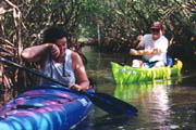
Its hard work paddling the narrow mangrove
tunnels. |
In many locations, the mangroves grow so close
together they form a canopy (tunnel) that completely encloses
the tidal creek. |
Access
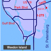
Weedon Island is located north of St. Petersburg on Tampa Bay.
The entrance of the Preserve can be found on the west side of the
Gandy Bridge (SR 92). Turn south on San Martin Blvd. Travel approximately
one mile and then east on Weedon Drive NE. Official address is 1500
Weedon Island Drive. The Weedon Island Cultural and Natural History
center is located about 1 mile from the entrance station. A canoe
launch, fishing pier and public restroom is at the end of Weedon
Drive.
Hours are dawn to dusk, 7 days a week. The Natural History center
is open Wednesday to Sunday from 10am to 4pm. Closed holidays. Guided
hikes and canoe trips are available by calling 727-453-6500.
| Important Items
Boat, Paddle, PFD
Take-apart, canoe paddle or pole
Insect Repellent
Environment
Saltwater Estuary
Mangrove Tunnels
Self-Guided Canoe Trail
Shallow water (1-5 feet)
Sea grasses
Native American Shell Mounds |
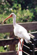
White Ibis. |
Tour: South Paddling Trail (4 miles)
It's recommended to make the trip at high tide. During low tide
you'll encounter what seems like miles of water less than two feet
deep. Be aware that tidal currents race through the narrow mangrove
tunnels and either provide push or additional exercise.
Begin at the canoe launch and head southeast into Papy's bayou
(away from the fishing pier). You'll quickly spot canoe trail marker
#1. The markers will be your guide for the duration of the trip.
As you reach each marker, be sure to be on the lookout for the next
one. The labyrinth-like maze of mangrove tunnels can easily confuse
the unsuspecting paddler. At marker 3, you will enter the first
mangrove tunnel. It's mandatory that you have a take-apart kayak
paddle or canoe paddle as the tunnels are quite narrow. The mangrove
tunnels offer much opportunity to see birds, fish and thousands
of small black crabs hanging out on the mangrove roots. The
tunnels also provide a haven for mosquitoes and other biting insects,
so use insect repellent. You've been warned!
After paddling for approximately 15 minutes, you'll reach a saltwater
pond at canoe marker #5. Cross the pond and enter the next set of
tunnels. Another pond and more tunnels follow. In this area is a
nice picnic spot, complete with tables and refuse containers. A
hiking trail goes from the picnic area to a parking lot (approximately
300 yards away). Continue following the canoe trail to reach Tampa
Bay. To the east lie Benjamin and Snake Islands. The trail continues
south in the protected waters between Weedon and Ross Islands.
The last set of mangrove tunnels puts you back in Papy's bayou
about one mile from the canoe launch. Look to the west to see the
observation tower and fishing pier. By following these landmarks,
you'll quickly find your way back.
Special Interest:
 Weedon Island has a very colorful and long history. The island
was originally inhabited by early Native Americans from approximately
10,000 BC to 1,200 AD. For the careful observer, it's easy to spot
elevated sections of ground that may be shell middens or burial
mounds. An example of a kitchen midden can be found at the start
of the boardwalk. This mound was originally over 10 feet high and
100 feet long. The midden was leveled during the 1930's when the
Grand Central Airport was built on Weedon Island. The airport is
no-more, but part of the foundation for the airport's office and
waiting room still exists. Weedon Island has a very colorful and long history. The island
was originally inhabited by early Native Americans from approximately
10,000 BC to 1,200 AD. For the careful observer, it's easy to spot
elevated sections of ground that may be shell middens or burial
mounds. An example of a kitchen midden can be found at the start
of the boardwalk. This mound was originally over 10 feet high and
100 feet long. The midden was leveled during the 1930's when the
Grand Central Airport was built on Weedon Island. The airport is
no-more, but part of the foundation for the airport's office and
waiting room still exists.
In more recent times, Weedon Island has seen development of a two
mile long boardwalk that meanders through the mangrove swamp and
the Cultural and Natural History Center in December 2002. The Paul
Getting Memorial Trail (boardwalk) follows the south paddling trail
through two saltwater ponds and the picnic area. The high point
(literally) of the boardwalk is an observation tower that reaches
45 feet above sea level. Three levels of stairs takes visitors to
an observation deck that provides a magnificent 360 degree view
of the St. Petersburg area.
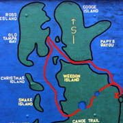
Weedon South Paddling Trail Map. |
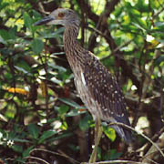
Juvenile Yellow-Crowned Night Heron. |
Map
|
GPS Location Aid
Description |
Latitude
Longitude |
Weedon Island put-in
Canoe Launch |
N27.50.643'
W82.36.688' |
Canoe Trail #5
Saltwater Pond |
N27.50.785'
W82.36.437' |
Canoe Trail #8
Saltwater Pond |
N27.50.871'
W82.36.205' |
Picnic Area
Canoe Dock |
N27.50.958'
W82.36.202' |
Tampa Bay Access
No Exit |
N27.50.916'
W82.35.953' |
|
|

