|
|
)
)
)
)
)
)
|
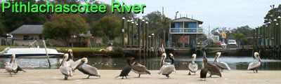
Description The Pithlachascotee River is an urban river located in the city of New Port Richey on Florida's central Gulf Coast. A trip along the Cotee (pronounced coat-e), as locals call it, offers canoeists and kayakers the opportunity to paddle twisty and shallow streams, a wide tidal influenced river and numerous saltwater bays.
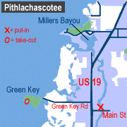
Access From US 19 and Main Street in New Port Richey, go one block north on US 19 and turn left on Green Key Road. Follow Green Key Road two miles to Robert K. Rees Memorial Park. Leave a car at the parking lot by the beach. Return to the intersection of US 19 and Main Street. Turn east (left) on Main Street and go two blocks to Sims Park. The boat ramp is behind the Chamber of Commerce building on the northwest side of the bridge. Parking is free.
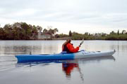
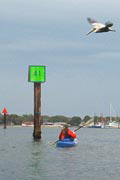
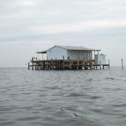
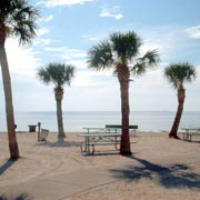
Tour #1: Sims Park to Green Key (6 miles one-way) This trip requires a shuttle from the take-out at Robert K. Rees Memorial Park on Green Key returning to Sims Park (River Road and Main Street) in New Port Richey. Leave one car at Robert Rees Park and take your primary vehicle (with boats and gear) to the put-in at Sims Park. To begin your Cotee adventure, start by paddling downriver. The tidal influenced current flows in a northwesterly direction towards the Gulf of Mexico. The first three miles of the trip pass through an urban setting with housing on both sides of the river. As you approach US 19, the river widens and you'll see a number of restaurants that make a great place to stop for lunch. All are boater friendly, and some have low docks or sandy beaches making it easy to land your canoe or kayak. Located by the restaurants and to the northwest of the US 19 bridge is HR Nick Park, a small Pasco county park with picnic tables, restrooms and boat ramp. This can be an alternative takeout point for those desiring a three mile trip. From HR Nick Park, follow the channel markers in a north then westerly direction to the Gulf. As you near the Gulf, you'll see several gray stilt homes approximately 1/2 mile into the water. These houses on stilts were used as vacation homes and fishing retreats until 1968 when Hurricane Gladys destroyed or damaged the majority of them. The State placed restrictions on rebuilding the houses following the hurricane. If you decide to check out the survivors, remember to hold your nose as pelicans and other birds use these homes as their private islands. Do not land or dock as trespassing is prohibited. From the southernmost stilt house, paddle 1.5 miles south along the mangrove shoreline to Green Key. As you approach Green Key you'll see a small covered observation deck that is part of the Robert K. Rees Memorial Park. At the southeast end of the island is the beach and take-out point. Tour #2: Sims Park to James E. Grey Preserve (6.5 miles) The 6.5 mile roundtrip from Sims Park to the James E. Grey Preserve covers much of the navigable areas of the Pithlachascotee River Canoe Trail. The lower section, from Sims Park to Francis Avenue City Park, is mostly residential with housing on both banks of the river. On weekends expect to encounter motor boat traffic. Upstream from Francis Park the river becomes much more remote, with only periodic signs of human occupation. Vegetation increases and you'll hopefully spot a variety of wading birds, alligators and turtles. To begin your journey, start at the boat ramp at Sims Park (directions at top of this page). Paddle upstream about 2 miles. You'll pass under two bridges. On the north bank of the river about 1/4 mile past the Madison Street Bridge (the second one), you should see a boat ramp. This is the Francis Avenue City Park ramp. The park has picnic tables, a playground for kids and restrooms. Going upstream from the Francis Park, you'll quickly start leaving civilization behind and enter some nice wilderness areas. Where the river appears to split, stay left. The right fork loops around the island and you'll end up right back where you started. After another mile paddling upstream, you should see a mobile home park on the south side of the river. Keep paddling as trespassing is discouraged (or so the sign says.) Another 1/4 mile and you'll see the new (2003) James E. Grey Preserve. The James E. Grey Preserve is about 80 acres of wetlands along the Pithlachascotee River. The park opened in 2003 and features a canoe launch, covered pavilion, picnic tables, restrooms, and several hiking trails. We found the park little used and very clean, but all of that could change as people discover this wonderful place along the river. To return to Sims Park in Port Richey, re-trace your path going downstream for 3.25 miles. If you have extra energy and a hankering to explore, about 100 feet down river from the mobile home park is a small creek on the right-hand side of the river. Following the twisty and narrow creek will take you to a large pond, complete with island within the James E. Grey Preserve. You should be able to spot a few picnic tables and a hiking trail. Special Interest If you are paddling the Cotee in late March, you don't want to miss the annual Chasco Fiesta. The fiesta started in 1922 as a way of honoring the romantic legend of a Spanish boy and girl and the Calusa Indian tribe who captured them. Today the fiesta features Native American festivals, arts & crafts shows, live entertainment, running races, and boat and street parades. It's good fun for the whole family and one of the Southeast's biggest events.
|
|||||||||||||||||||||||||||||||||